Sierra High Route
Maps and Itinerary
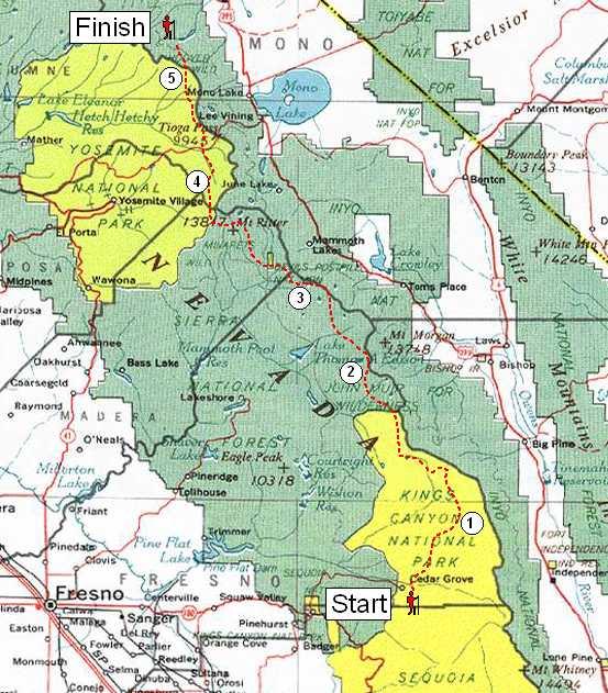
The journey was comprised of five stages, each taking about a week
to complete. The route travelled from south to north.
The maps on the subsequent pages represent early
plans and are different from the actual route we hiked, as shown below.
Actual Itinerary
Below is the itinerary of where I hiked and camped for each day of the
journey.
John's Big Sierra Hike - Actual Itinerary                                   Miles: Trail   XC


S  23-Jul           Drive to SEKI - camp Sunset Campground
S  24-Jul           Drive to Kings Cyn - camp Sentinel Campground
M  25-Jul Rendezvous - Kings Cyn - Cedar Grove
T  26-Jul Stage 1 Begins - Depart Roads End - Camp Paradise Valley                 8.4
W  27-Jul           Hike Woods Crk, Camp drainage W. of Window Peak                2.2     1.5
Th 28-Jul           Camp Arrow Basin, W. of Pyramid Pk                                     3.8
F  29-Jul           Hike Arrow Pass.  Camp at tarn west of Bench Lk overlooking S. Fork    3.4
S  30-Jul           Hike JMT to Upper Basin.                                       7.3       1
S  31-Jul           Hike Mather Pass. Hike JMT to Palisade Lake. Cross Cirque pass 4.5     1.3
M  01-Aug           Layover
T  02-Aug           Cross Potluck pass, camp Barrett Lakes Basin, recon N. Pal.            1.3
W  03-Aug           Climb North Palisade.                                                 0.75
Th 04-Aug           Hike Knapsack Pass, Dusy Basin, Bishop Pass, exit South Lk     3.5       6
F  05-Aug           resupply - Four Jeffrey site #7
S  06-Aug           resupply
S  07-Aug Stage 2 Begins - Depart Lk Sabrina - Camp Sailor Lk.                       5
M  08-Aug           Cross Haeckel Col. Camp Sapphire Lk                                    3.8
T  09-Aug           Hike JMT to Evolution Lk. Hike Darwin Bench. Cross Alpine Col  1.9     4.8
W  10-Aug           Cross Humphrey's Basin, hike French Cyn, Camp Merriam Lk         2     7.5
Th 11-Aug           Cross Feather Pass. Climb Feather Pk. Camp Black Bear Lk               3.6
F  12-Aug           Lake Italy (noon) - Camp tarn South of Gabbot Pass.                    4.7
S  13-Aug           Hike Gabbot Pass - camp Lower Mills Creek                              2.3
S  14-Aug           Hike Mono Crk Trail. Exit Lake Edison - Camp Vermillion        7.1       3
M  15-Aug           resupply
T  16-Aug Stage 3 Begins - 4pm depart ferry - bivvy west of Quail Meadows.           1
W  17-Aug           Hike JMT to Pocket Mdw, hike to Mott Lk, xc to Bighorn Lk.     5.8       1
Th 18-Aug           Climb Mt. Izaak Walton, camp Izaak Walton Lk                          2.76
F  19-Aug           Hike xc to Fish Creek. Hike JMT to Lk Virginia, xc to Glen Lks   4       1
S  20-Aug           Hike xc to Purple Lk, Hike to Duck Lk, XC over Mammoth Plateau 4.9     2.3
S  21-Aug           Hike over Mammoth Crest, exit Crystal Lk Trailhead - camp      5.1
M  22-Aug           Resupply
T  23-Aug           resupply
W  24-Aug Stage 4 Begins - Depart Devils Postpile Trailhead - Hike Minaret Crk     6.5
Th 25-Aug           Hike Cecile Lk, cross Whitebark Pass, Camp west of Garnet Lk           4.7
F  26-Aug           Cross N. Clacier Pass, Camp Twin Island Lk                             5.8
S  27-Aug           Hike to Bench Cyn                                                        2
S  28-Aug           Hike to Blue Lk, Climb Foerster Pk.  camp Blue Lk                        3
M  29-Aug           Cross Pass Blue Lk Pass, Hike Isberg Trail through Lyell Fork  4.5     3.1
T  30-Aug           Hike Lewis Creek, cross Vogelsang Pass, Camp Vogelsang Lk      5.7
W  31-Aug           Hike Rafferty Creek trail, Exit Tuolumne Mdws (pm)             6.2
Th 01-Sep           resupply
F  02-Sep           rest
S  03-Sep Stage 5 Begins - camp Sawmill Campground
S  04-Sep           Day Hike - Fantail Lk, Bennetville, Great Sierra Mine, Spuller Lk     7.25
M  05-Sep           rest
T  06-Sep           Ferry Saddlebag Lk - Camp Cascade Lk                          1.25     0.5
W  07-Sep           Cross McCabe Pass, Camp McCabe Mdw                                     2.9
Th 08-Sep           Hike Cold Cyn - Camp near Glen Aulin                          8.25       1
F  09-Sep           Hike Murphy Crk, xc to Poly Dome Lakes, exit nr Low Profil     4.7    1.75
S  10-Sep           return to SLO

                                                                          total     99.8   87.81
Distances
 The
numbered circles on the map correspond to the stages of the trip.
Stage 1 - (38 miles) Kings Canyon to
South Lake
(near Bishop)
Stage 2 - (65 miles) South Lake to Lake
Edison
Stage 3 - (32 miles) Lake Edison to
Devil's
Postpile
Stage 4 - (42 miles) Devil's Postpile
to Tuolumne
Meadows
Stage 5 - (28 miles) Tuolumne Meadows
to Twin Lakes
View Enlarged Overview Map [330KB]
Stage Difficulty Ranking (Easy to Hard)
5 -> 3 -> 4 -> 2
-> 1
 The
numbered circles on the map correspond to the stages of the trip.